Nepal Is Open, and a New Road Leads You There
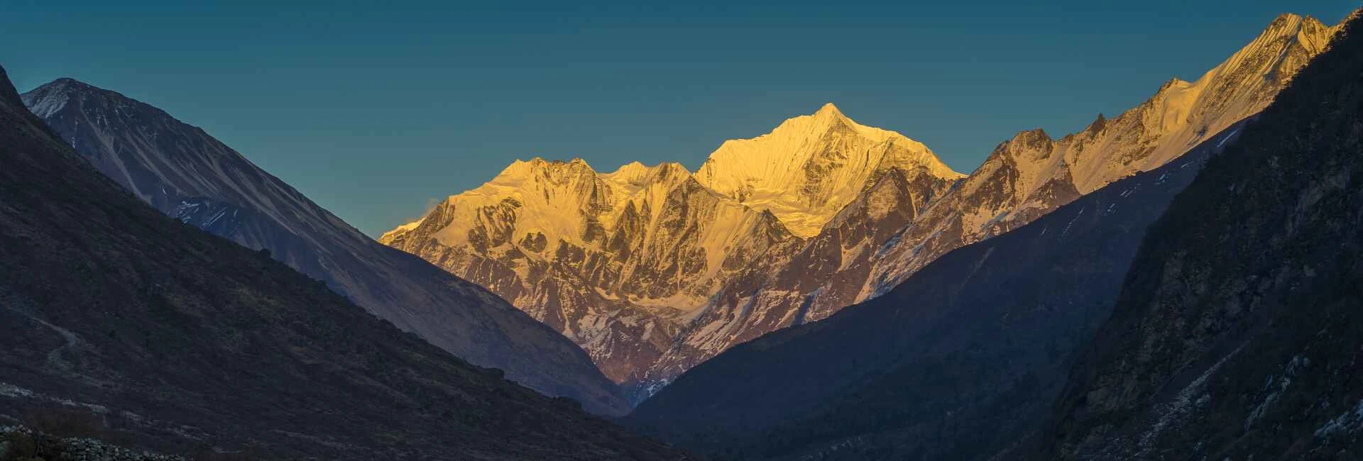
There's a quiet magic to the Langtang Valley that has drawn trekkers for decades glacier-draped peaks rising directly above ancient Tamang villages, prayer flags snapping in thin mountain air, and a stillness that feels like stepping back in time. Following recent flooding that affected parts of the traditional access road, a new alternative route into Rasuwa district has opened, reconnecting Kathmandu to Dhunche and, from there, the full Langtang Gosaikunda trekking trail. The mountains, the monasteries, and the valley of glaciers are open and ready to welcome you again.
Before You Read Further
This guide reflects the trekking route to Langtang Valley as it currently stands in the aftermath of the August 26, 2026 glacial collapse and debris flow that struck the Bhote Koshi and Trishuli river corridors in Rasuwa district. The route below including the access road to Dhunche is based on the government-designated alternative corridor currently in use, since the traditional highway remains damaged. That said, road and trail conditions in this region are changing week to week as repair work continues. Treat the details here as a snapshot, not a guarantee, and verify current conditions with a registered Nepali trekking agency or the Rasuwa District Administration Office before finalizing any trip. For a fuller picture of the disaster response and how to help, see our Nepal Flood 2026 rescue and relief update.
What Happened, and Why the Route Has Changed
On August 26, 2026, a mass of ice and rock broke away from the north flank of the Langtang Himal at roughly 5,600 meters, inside Langtang National Park. The failure mobilized into a debris flow that entered the Bhote Koshi at the Rasuwagadhi border crossing and continued down the Trishuli, with USGS estimating a total runout of close to 100 kilometers. The Trishuli reportedly rose by as much as 9 meters in just 30 minutes, and the front of the flow moved at an average speed of roughly 193 km/h over its first 22 kilometers, an almost unimaginable pace for a wall of ice, rock, and water.
The damage was severe and heavily concentrated along the river corridor and the settlements built beside it. Timure, Syabrubesi, Trishuli Bazaar, and portions of the Rasuwagadhi border route sustained severe impacts, while connecting mountain highways through parts of Nuwakot and Dhading experienced temporary blockages and bridge washouts. The human cost was significant, and search and recovery operations continued for weeks afterward; full details are covered in our flood relief and donation update.
This is why the traditional road to Langtang, the one that ran directly alongside the Trishuli River through Betrawati and Syabrubesi, is currently compromised. An inspection of the stretch between Trishuli Bazaar and Betrawati found that the river had completely washed away roughly 4 of its 10 kilometers. Within Rasuwa district alone, floods swept away 13 bridges, with two more destroyed along the Nuwakot-Rasuwa border, cutting the district off from the road network entirely for a period.
In response, Nepal's disaster authorities opened an alternative corridor through the mid-hills north of Kathmandu, reconnecting Rasuwa to the road network for small four-wheeled vehicles. That corridor is the route this itinerary now follows.
The New Route In: A Detour Worth Taking
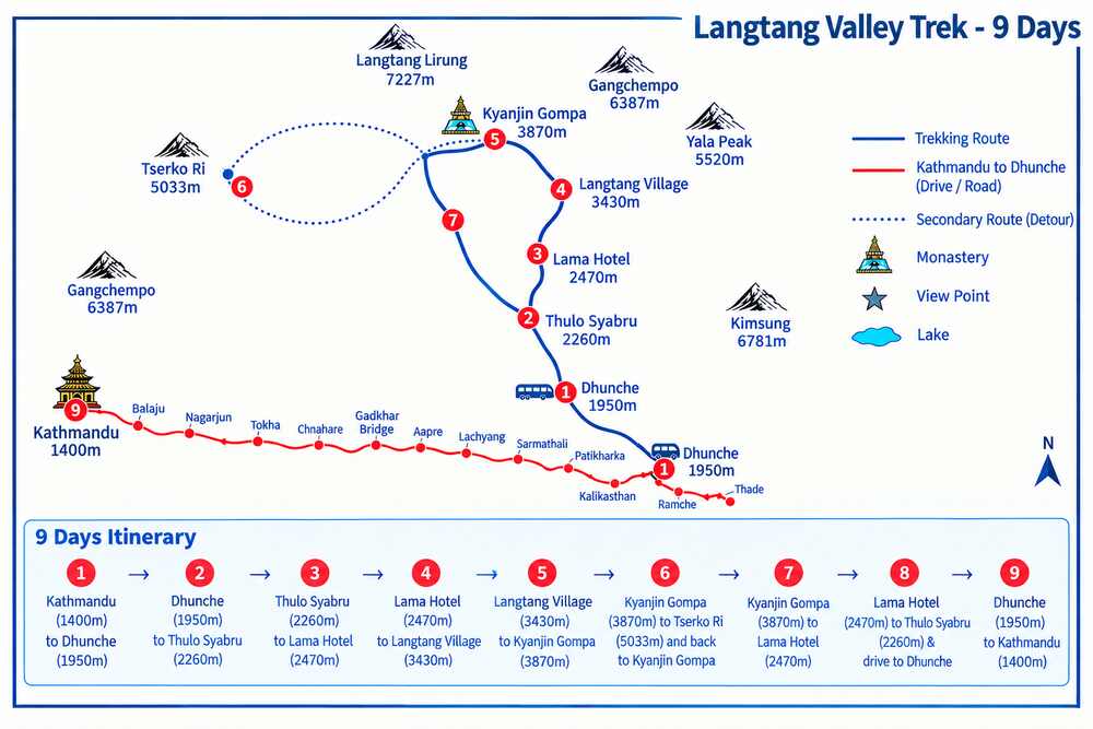
Forget everything you remember about the drive to Langtang. The old highway hugged the Trishuli River in a straight, familiar line. The new route does something entirely different: it climbs.
Rather than tracking the river, the road now threads its way up and over Nepal's mid-hills, a corridor that didn't exist on most trekkers' radar until the flood made it necessary, and turned out to be a quiet reward in disguise.
The route, stop by stop:
| Leg | What to Expect |
|---|---|
| Kathmandu → Tokha | Leaving the valley floor behind |
| Tokha → Chhahare | The first real climb into the hills |
| Chhahare → Gadkhar Bridge | A stream crossing marking your exit from the city's edge |
| Gadkhar Bridge → Aapre → Narja → Lachyang | A string of terraced hillside villages, one folding into the next |
| Lachyang → Sarmathali → Patikharka → Bogtitar | Ridgeline views opening and closing with every curve |
| Bogtitar → Kalikasthan | Forest thickens, pine and rhododendron crowding the road |
| Kalikasthan → Dhunche | The final descent into Rasuwa's district headquarters |
What makes this route worth talking about isn't just that it works, it's that it shows you a Nepal most itineraries skip entirely. Terraced farmland cut into steep hillsides. Farmers working fields their families have tended for generations. Small settlements that have likely never seen a trekker pass through, let alone stop for tea.
A few things worth knowing before you go:
| Consideration | Why It Matters |
|---|---|
| It's longer | Narrower, newer, and less direct than the old highway, this route adds real hours to the drive. Budget a full travel day, not a half one. |
| Leave early | An early departure from Kathmandu isn't a suggestion, it's the difference between arriving in daylight and arriving in the dark. |
| It's scenic in its own right | This isn't a detour to endure before the "real" trek starts. The ridgeline views, the forest cover, the hillside villages, this is the trek beginning a day earlier than you expected. |
It's a small trade-off, and an easy one to make, for a road that keeps this extraordinary region connected, accessible, and open for the journey ahead. If road conditions or timing are a concern, Outshine Adventure's team can confirm the latest status before you set out.
Your 9-Day Journey to the Valley of Glaciers
Day 1: Kathmandu to Dhunche The adventure begins early, pulling out of the Kathmandu Valley while the morning air is still cool and the city is just waking up. The government-designated hill route carries you first through Tokha, on the valley's northern edge, then climbs into quieter terrain through Chhahare and across the Gadkhar Bridge, where the sound of a rushing stream below marks your first real sense of leaving the city behind. From here, the road winds through a string of small hill settlements: Aapre, Narja, Lachyang, Sarmathali, Patikharka, and Bogtitar, each surrounded by terraced fields cut into the hillsides, farmers tending crops much as they have for generations, and views that open and close as the road curves along the ridgelines. Forest cover thickens the higher you climb, with pine and rhododendron lining the route, until the road crests near Kalikasthan and begins its final descent into Dhunche, the headquarters of Rasuwa district and your gateway to the Langtang region. It is a long day on the road, but one filled with the kind of unhurried, off-the-beaten-path scenery most trekkers never get to see, and you'll arrive in Dhunche as evening settles over the surrounding hills.
Day 2: Dhunche to Thulo Syabru Leaving the roadhead behind, the trail begins its climb toward Thulo Syabru, a village perched high on a ridge with sweeping views back across the valley you just drove through and out toward the surrounding hills of Rasuwa. It's a shorter, steadier day than what follows, a gentle introduction to trekking at altitude before the trail drops into forest tomorrow. Arriving in Thulo Syabru by early afternoon leaves time to settle into the teahouse, wander the village's stone lanes, and take in the views before the trail turns downhill into the Langtang Khola valley.
Day 3: Thulo Syabru to Lama Hotel From Thulo Syabru, the path drops down into dense subtropical forest, where sunlight filters through a canopy of oak, rhododendron, and bamboo, and the calls of birds, along with the occasional rustle of langur monkeys in the branches overhead, accompany your walk. The trail hugs the Langtang Khola for much of the way, crossing swinging suspension bridges over the glacial-fed river as it winds gradually upward. By late afternoon, the cluster of teahouses at Lama Hotel comes into view, tucked into the trees, a warm and welcoming stop for your first night truly immersed in the mountains.
Day 4: Lama Hotel to Langtang Village The trail continues climbing steadily through forest that slowly begins to change character, passing Riverside, where the river's roar is a constant companion, and Ghoda Tabela, a former army post and horse-grazing meadow that opens into your first real sense of the valley's scale. Continuing on through Thangshyap, the dense forest gradually gives way to more open terrain, and for the first time the high peaks surrounding the valley come clearly into view, a striking moment after two days spent mostly under tree cover. Langtang Village itself, at roughly 3,430 meters, holds a special resonance. Rebuilt with quiet determination after the 2015 earthquake, it stands today as a living testament to the strength of the Tamang communities who call this valley home, and its warmth and hospitality make for a memorable overnight stop.
Day 5: Langtang Village to Kyanjin Gompa The trail climbs higher still, passing through the small settlements of Mundu and Sindum, where the valley begins to widen dramatically and yak herds graze across open pastureland. The surrounding peaks close in more tightly here, creating a genuine sense of standing deep within the high Himalaya. By the time you reach Kyanjin Gompa, at 3,850 meters, the full grandeur of the upper valley is on display: a centuries-old Buddhist monastery framed by the towering, glaciated wall of Langtang Lirung rising almost directly overhead, and a small, welcoming settlement that has long served as base camp for exploring the valley's highest reaches.
Day 6: Kyanjin Gompa to Kyanjin Ri / Tserko Ri and back to Kyanjin Gompa A day built for both rest and reward. Most trekkers use this acclimatization stop to climb higher for even better views. Kyanjin Ri offers a shorter, more accessible ascent with a strong panoramic payoff, while the more demanding climb to Tserko Ri rewards those who make the effort with a sweeping 360-degree view stretching across Langtang Lirung, Langshisha Ri, and a seemingly endless procession of snow-capped ridgelines toward the Tibetan border. Either route offers a chance to properly acclimatize while taking in some of the most spectacular mountain scenery of the entire trek, before returning to Kyanjin Gompa for a well-earned rest.
Day 7: Kyanjin Gompa to Lama Hotel The descent begins, retracing your steps back down through Sindum, Mundu, Langtang Village, Thangshyap, and Ghoda Tabela. Walking the same trail in reverse offers a surprisingly different experience. Details missed on the climb up now catch your eye, the light falls differently across the valley, and there is a quiet satisfaction in covering familiar ground with the summit views still fresh in memory. By evening, the forested surroundings of Lama Hotel welcome you back for the night.
Day 8: Lama Hotel to Thulo Syabru & Drive to Dhunche The final trekking day brings a mix of nostalgia and accomplishment as the trail climbs back up through the same forest trails, crossing the Langtang Khola's suspension bridges one last time, birdsong and the rustle of langur monkeys accompanying the walk back to Thulo Syabru, a last chance to soak in the sounds and scenery of the valley on foot. From Thulo Syabru, rather than trekking the remaining descent, a short jeep transfer carries you down to Dhunche, easing you back into the world of roads and vehicles and leaving time to rest before tomorrow's longer drive to Kathmandu.
Day 9: Dhunche to Kathmandu The journey concludes with the return drive along the same government-designated route, retracing your path back through Kalikasthan, Bogtitar, Patikharka, Sarmathali, Lachyang, Narja, Aapre, the Gadkhar Bridge, Chhahare, and Tokha, before finally arriving back in Kathmandu. It is a long day of travel, but one that closes out the trip with the same unhurried, scenic hill roads that opened it. Mountain memories, and a little trail dust, come along for the ride.
Best Time to Trek
Spring (March–May) brings rhododendron blooms through the lower and middle valley and generally clear skies for mountain viewing.
Autumn (September–November) is traditionally the most reliable season, with stable weather and the clearest high-altitude views though this year, autumn also coincides directly with ongoing post-flood recovery work, which is worth factoring into timing.
Winter (December–February) is feasible for well-prepared, experienced trekkers, with snow adding difficulty above Kyanjin Gompa.
Monsoon (June–August) carries the least favorable conditions under normal circumstances, and given this disaster's direct connection to heavy rainfall and slope instability, extra caution is warranted in this region during future monsoon seasons.
Permits
- Langtang National Park Entry Permit
- TIMS Card (Trekkers' Information Management System)
Given the current situation, it's worth checking directly with the National Park office and the Rasuwa District Administration for any additional route advisories or restrictions beyond the standard permit requirements. Permit rules have also shifted more broadly across Nepal this year; see our guide to Nepal trekking rules, permits, and the solo trekking ban in 2026 for the current requirements and why booking through a TAAN-registered agency matters more than ever.
The Valley of Glaciers Is Calling
Few treks in Nepal offer this particular balance of accessibility and wonder. In just a matter of days, you can travel from the noise and energy of Kathmandu into a valley carved by glaciers, ringed by peaks that have watched over these communities for centuries, and dotted with monasteries where prayer wheels turn in silence and butter lamps flicker against cold stone walls. It is a landscape that shifts constantly as you walk through it: dense subtropical forest giving way to alpine pasture, glacial rivers cutting through valleys, and finally the wide, open expanse of the high Himalaya, with Langtang Lirung standing sentinel above it all.
To walk into Langtang now is to witness a place in the middle of its own comeback, still every bit as breathtaking as it has always been, but carrying with it a deeper story of endurance. The glaciers still hang from the ridgelines. The monasteries still stand. The trails still wind through forest and pasture up toward Kyanjin Gompa and beyond. What has changed is the road that gets you there, and even that new route, winding through terraced hillsides and forgotten hill villages, has become part of the story worth experiencing.
Navigating a route this fresh, on trails still finding their post-flood footing, is exactly where a good local team makes the difference. Outshine Adventure, a Kathmandu-based trekking and expedition company with years of experience across the Nepal Himalaya, can help you plan and lead this journey with current, on-the-ground knowledge of road conditions, permits, and the alternative corridor into Rasuwa. Their guides work directly within the communities along these trails, so you're not just passing through the valley, you're walking it with people who know it, and who are personally invested in its recovery. Read more about why trekkers choose to travel with us, or get in touch to start planning.
With the government-designated corridor now open, the trail ahead as spectacular as it has ever been, and experienced hands ready to guide the way, the Langtang Gosaikunda trek stands ready for its next chapter, and it is one worth being part of. Nepal is open. The mountains are waiting, patient as they have always been. And the road to the valley of glaciers, however it has changed, still leads right to your doorstep.