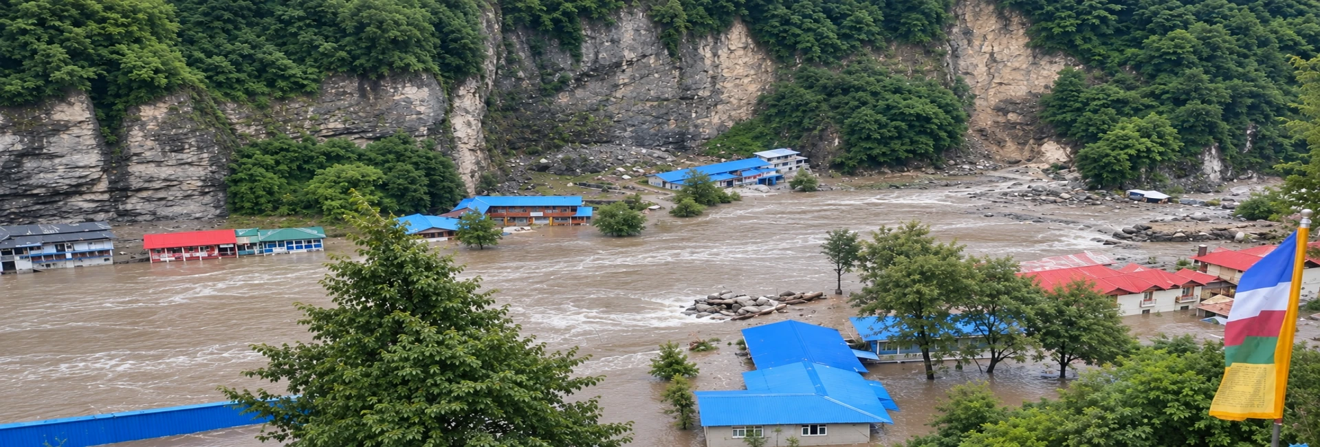
Key facts at a glance
- When: Sunday, 27 September 2026, with recovery reported on Monday, 28 September
- Where: Ghatte Khola and the Marsyangdi river at Chame, Manang district, Gandaki Province
- What happened: A flood and landslide on Ghatte Khola partially blocked the Marsyangdi and formed a lake
- Response: Villagers moved to an army barrack and forest shelters, and a warning siren sounded along the river
- Now: The water has dropped by about a metre, the river flows more freely, and people are returning home
- Separate event: An avalanche hit Himlung Himal Base Camp in Nar Phu on the same day, with two guides confirmed dead and 14 staff still missing
Introduction
Manang is a high Himalayan district that most travelers know as the middle stretch of the Annapurna Circuit. It is a place of stone villages, prayer flags, apple orchards and views of Annapurna II and Gangapurna. On Sunday, 27 September 2026, that calm broke. A debris-laden flood from a small stream partially blocked one of central Nepal's major rivers, hundreds of villagers spent the night in caves and forest shelters, and a deadly avalanche struck a remote base camp in the same district.
This article explains what happened, why a small stream can threaten a large river, what the weather was doing, and what it means for anyone planning to visit Manang, whether as a trekker, a guest at a mountain lodge, or a traveler on the road to Chame.
Understanding the setting: Manang and the Marsyangdi
The Marsyangdi is one of the main rivers of central Nepal. It rises in the high Manang area and flows down through Lamjung toward the plains, following a deep valley that also carries the trail and the road toward Manang. Chame, the district headquarters, sits along this river. Many bridges, lodges, offices and homes stand close to the banks because the valley floor is narrow.
That geography explains why a blockage matters. In a wide plain, a landslide might spread out and cause limited harm. In a narrow mountain gorge, the same debris can plug the whole channel, and water has nowhere to go but up.
Why a small stream can block a big river
Ghatte Khola is a tributary, and in normal weather it is small. In heavy rain, steep mountain streams can carry huge loads of mud, gravel, boulders and timber. When such a flood reaches a larger river, the debris can settle across the channel like a plug.
Three risks follow:
- Upstream flooding. Water builds up behind the plug and forms a lake, which submerges bridges, fields and buildings.
- Sudden release. If the plug gives way, the stored water can surge downstream as a flash flood with far more force than normal river flow.
- Repeat landslides. Slopes that have already failed are often unstable for days, and new slides can add to the blockage.
This is why authorities took a river blockage seriously even though water levels looked manageable at first. In the Chame case, the Chief District Officer said the river had been flowing through a narrow channel on Sunday and was flowing more freely on Monday. He also said the area remained at risk because of the mud and debris the river had deposited, though the danger was receding.
Where things stand now
As of Monday, 28 September, the picture is cautiously positive. Police Inspector Binod Bohara, acting chief of the District Police Office in Manang, said the situation had been improving since the morning, with bright sunshine and no new landslides. The lake in Chame had dropped by about a metre compared with Sunday, and evacuees were heading home.
Still, "improving" does not mean "finished." Loose debris, softened banks and damaged trails or roads can stay hazardous for days after the water drops. Local officials continue to monitor the site.
A second emergency: the Himlung Himal avalanche
On the same Sunday, an avalanche swept through Himlung Himal Base Camp in Manang's Nar Phu area. Himlung stands at 7,126 metres near the Tibet border. The Expedition Operators Association Nepal first reported at least 10 expedition staff missing, most of them support workers from two expedition companies. The Nepal National Mountain Guide Association later said two guides had been found dead and 14 kitchen staff were still missing, raising the total to 16.
Reuters reported that the workers were setting up tents for foreign climbers, who were not at the camp when the avalanche hit. The Himalayan Times noted that many other climbers and support staff had already moved to lower ground after weather agencies warned of heavy rain, snowfall and higher avalanche risk.
Numbers in the first hours changed several times because the site is remote and contact was difficult, so readers should rely on the latest official updates. The Himlung event is separate from the Chame flood, but both came from the same stretch of severe weather.
The weather behind the disaster
This weekend did not come as a complete surprise. The Department of Hydrology and Meteorology had warned that a low-pressure system over the Bay of Bengal could bring extremely heavy rain to Nepal between 24 and 28 September. DHM classifies rainfall above 200 mm in 24 hours as extremely heavy. The department also noted that the monsoon trough was sitting south of its normal position, and that Nepal was under the partial influence of both the monsoon and westerly winds.
Timing matters here. Nepal's monsoon normally withdraws around 2 October, but it has often left later. Last year it fully withdrew on 10 October, eight days late, according to DHM. Tribhuvan University's Binod Pokharel said heavy October rain has become a recurring feature over the past five years. In plain terms, the end of the monsoon can still be dangerous, and trekkers who assume the rains stop on the calendar date may be caught off guard. If you are still choosing your dates, our guides to the best time for trekking in Nepal and the best year to trek in Nepal in 2026 explain how the seasons work.
The wider region felt the same system. Al Jazeera reported that the Uttar Pradesh relief commissioner linked heavy rain in northern India to a depression that moved inland from the Bay of Bengal, and Nepal recorded a fresh set of deaths from floods and landslides since Thursday.
The wider picture across Nepal
Manang was one of many affected areas. Nepali authorities warned of possible flash floods in 49 of the country's 77 districts, with more than half facing a high flood or flash flood risk as river levels kept climbing. Al Jazeera reported at least 12 deaths in Nepal since Thursday, weeks after the late August floods that killed more than 1,400 people. Reuters added that floods and landslides had disrupted telecommunications in parts of the country because of damage to optical fibres and power supplies.
For a traveler, the last point is especially relevant. Even if your route is untouched, the phone or internet service you rely on to check conditions may fail. For background on how the August floods affected trekking, see our post on whether it is safe to book a Nepal trek after the floods.
What this means for travelers
Every trip is different, but a few practical realities apply to anyone heading to Manang or the Annapurna Circuit in the coming weeks.
Roads and trails can change overnight. A trail that was fine yesterday may have a fresh slide across it today. Bridges may be submerged or weakened. Vehicle roads along river valleys are often the first to close and the last to reopen.
Higher does not always mean drier. Manang sits in a partial rain shadow and gets less direct monsoon rain than the lower valleys, but storms that dump rain in the foothills can drop heavy snow on high passes and side valleys. The Himlung avalanche is a sharp reminder of that.
Flexibility is the best protection. A tight itinerary leaves no room for a two-day road closure or a pass that needs a weather delay.
Local knowledge is quicker than the internet. Lodge owners, drivers and licensed guides often know about a closed bridge or a swollen stream hours before any online update appears.
Where to find reliable updates
Official and established sources are far more dependable than social media in a disaster. Useful places include the District Administration Office in Manang, the National Disaster Risk Reduction and Management Authority, the Department of Hydrology and Meteorology (dhm.gov.np), and national newspapers such as The Kathmandu Post, The Himalayan Times, OnlineKhabar and Radio Nepal. Trekking operators also publish status notes, such as Outshine Adventure's travel advisory for Nepal.
Be careful with images and videos that spread quickly online. After major disasters, old footage and edited or AI-generated clips often circulate as if they were new.
Frequently asked questions
Is the Marsyangdi river still blocked at Chame?
The lake formed on Sunday has dropped by about a metre and the river is flowing more freely, according to Manang's Chief District Officer. Authorities are still watching the site.
Were there deaths in the Chame flood?
The reports reviewed for this article described evacuations and flooding but did not mention deaths from the river blockage itself. Check the latest official updates, since situations can change.
Is the Annapurna Circuit open?
Conditions differ by section and change quickly. Confirm the state of roads, bridges and passes with local authorities or a licensed operator before you go. You can also read the full Annapurna Circuit Trek itinerary and guide for the route, altitude profile and permits.
Is the Himlung avalanche connected to the Chame flood?
Both took place in Manang on the same day during severe weather, but they are separate events in different locations.
When does the monsoon end in Nepal?
The normal withdrawal date is around 2 October, but recent years have seen later exits, and heavy rain in October has become more common.
What should I do if I am in Manang during a flood warning?
Move to higher ground, stay away from rivers and bridges, and follow instructions from police, army and local officials.
Conclusion
The Chame river blockage has eased, and families are returning to their homes. The Himlung avalanche has left many waiting for news, and our thoughts are with the families of the guides and workers affected.
For travelers, this weekend shows how quickly mountain conditions change and how much value there is in local information, spare days and a cautious plan. Nepal's mountains remain one of the world's great travel destinations, and they are best visited by people who respect their weather.
If you are planning a trip to Manang or the Annapurna region this season and want current route and weather information from a local team, you can get in touch with Outshine Adventure before you book or set out, or browse our featured trips for ideas.