Last updated: October 6, 2026
For many trekkers, the Annapurna Circuit is the walk that defines a Himalayan trip. It starts in warm, green foothills, climbs through pine forest and apple orchards, passes monasteries and prayer walls in the high Manang valley, and finishes with a crossing at 5,416 meters, one of the highest trekking passes in the world. October is when it all comes together, with the monsoon cleared away and the snow peaks showing sharp against the sky.
This year, the lead-up to that season has been unsettled. Landslides and flooding across the region closed roads, paused permits, and left trekkers unsure whether their plans were still possible. Official status has changed several times in recent weeks, and it has now moved in a better direction. This page explains what has reopened, what is still disturbed, and what each update means for the stage of the trek you are planning.
Everything below is based on notices from the Annapurna Conservation Area Project (ACAP) and the Trekking Agencies' Association of Nepal (TAAN). We revise the page whenever a new notice appears, and the date at the top shows when it was last checked.
The Short Answer: Is the Annapurna Circuit Open?
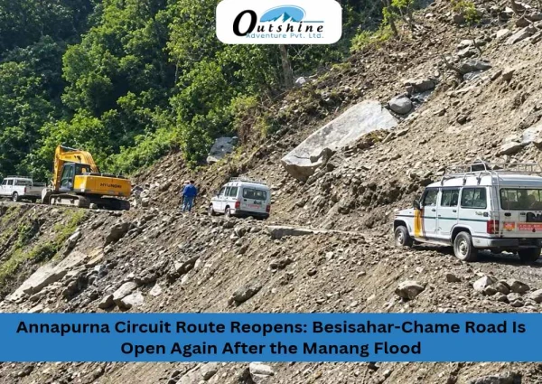
Largely, yes. ACAP is issuing permits again, the road from Besisahar to Chame reopened on October 3, 2026, and a group of trekkers crossed Thorong La Pass the same day. The vehicle road between Chame and Bhratang is still disturbed, but the walking trail on that stretch is open.
On October 5, a new landslide carrying mud and debris hit Koto in Chame Rural Municipality. We have not yet found an official notice on its effect on the road, so check the latest status with your operator before you travel.
Trail Status at a Glance
| Item | Current status | Source date |
|---|---|---|
| ACAP permits | Being issued again | Early October 2026 |
| Besisahar to Chame road | Reopened after about six days blocked | October 3, 2026 |
| Chame to Bhratang road | Still disturbed | October 3, 2026 |
| Chame to Bhratang trekking trail | Open | October 3, 2026 |
| Thorong La Pass | Crossed by a group of 7 trekkers | October 3, 2026 |
| Koto (Chame Rural Municipality) | New landslide with mud and debris reported; effect on the road not yet confirmed | October 5, 2026 |
| Manang checkpoint | Clearing trekkers toward Yak Kharka and High Camp | October 4, 2026 |
What Happened: The Chame and Koto Landslides
The disruption came in the last days of September, and the pictures of it have been widely shared.
September 27: flood and landslide at Chame. Continuous rain triggered floods and landslides across Chame. Mud entered the settlement, and local reports say about five houses were swept away and two wooden bridges destroyed. Residents fled to nearby forest overnight, and no casualties were reported at the time. Trekkers were among those stranded without road access.
The Marsyangdi was partly dammed.We covered the first days of this flood in our earlier report, Manang Flood and Landslide: Marsyangdi Blocked at Chame.) A landslide and debris flow, linked to the Ghatte Khola stream, reduced the flow of the Marsyangdi River at Chame. Authorities issued a high alert for downstream areas. The river was reported to be flowing more freely by the next day, though officials said the mud and debris left behind remained a risk. A Nepal Army technical team went to Chame to assess controlled blasting.
Landslides along the road. Slides struck repeatedly between Besisahar and Chame, including at Khotro in Nason Rural Municipality and at Koto in Chame Rural Municipality. One report said the Besisahar to Chame road lost about 200 meters of its width at Kharkhere Bhir.
October 3: road cleared. Once the slides at Khotro and Koto were cleared, the Besisahar to Chame road reopened to vehicles, six days after it was blocked.
October 5: another landslide at Koto. Two days after the reopening, a landslide carrying mud and debris hit Koto in Chame Rural Municipality. We get to informed that persistent rainfall has set off recurring floods and landslides across parts of Manang, repeatedly disrupting life in the area. At the time of writing we have not found an official notice on whether this slide has blocked the road again, so treat the road as open but at risk.
Nepal has also seen wider damage from the same rain spell. Media reports cite at least 17 deaths nationally since late September, and trekkers were helicoptered out of several mountain areas. That is a reminder that the situation remained serious even where the circuit itself has reopened.
Why the Circuit Is Prone to Disruption
To understand why a few days of heavy rain can change the status of a whole trek, it helps to picture the terrain. The Annapurna Circuit follows the Marsyangdi River upstream through a deep, steep-sided valley. The slopes above the trail and the road are made of loose rock and soil that the monsoon saturates through the summer. When intense rain arrives, hillsides can slide, rivers can rise, and a single blocked section can cut off the road for everyone beyond it.
The circuit also depends on a road for its early days. A rough vehicle road now follows much of the lower valley, and many trekkers use it to save time. When that road is damaged, jeeps stop, and operators have to decide whether to walk the section, wait for repairs, or adjust the plan. That is why you often hear two different statuses at once: the road is closed, but the trail is open. Both can be true, and the current Chame to Bhratang situation is an example.
What Has Been Confirmed, Stage by Stage
The easiest way to read the notices is to follow the route in order.
Permits: Back for the Whole Conservation Area
ACAP has confirmed that permits for all trekking routes in the Annapurna Conservation Area are being issued again. This covers the Manang region, which includes the main circuit, as well as Jomsom and Upper Mustang, and the shorter treks around Ghandruk, Lwang, and Sikles. For anyone who delayed a trip because permits were paused, this removes the first obstacle.
Besisahar to Chame: The Road Is Open
The classic start to the circuit is a long drive from Kathmandu to Besisahar, the district town where the trail traditionally begins, followed by a ride up the Marsyangdi valley. As the road climbs, the air cools, rice terraces give way to pine, and the mountains begin to fill the horizon. Chame, the headquarters of Manang district, is the larger town that marks the start of the high valley. The road from Besisahar to Chame reopened on October 3, 2026, which restores the standard access route for the first part of the trek.
Chame to Bhratang: Walkers Can Pass, Vehicles May Not
This is the one section still flagged by the notices. The vehicle road between Chame and Bhratang remains disturbed, so jeeps and buses may be delayed or unable to continue. The trekking trail on the same stretch is separate from the road and is open. For people on foot, the route carries on. If your itinerary includes a vehicle for this section, ask your operator how they are handling it.
Manang: The Gateway to the High Section
Manang sits at about 3,540 meters in a wide, dry valley below Annapurna III and Gangapurna. It is the main acclimatization stop on the circuit (the rest day is built into our Annapurna Circuit itinerary), where trekkers usually spend a full rest day, take a short walk to a higher viewpoint, and let their bodies adjust before climbing further. On October 4, ACAP's Manang checkpoint was clearing trekkers to continue toward Yak Kharka and High Camp.
Yak Kharka, Thorong Phedi, and High Camp
Above Manang, the villages thin out and the trail climbs through open, treeless terrain. Yak Kharka lies at about 4,000 meters, and Thorong Phedi at about 4,450 meters is the traditional base before the pass. High Camp sits higher still, which shortens the climb on pass day but also means a night at greater altitude. Each step upward asks more of your body, which is why steady pacing matters more here than speed.
Thorong La Pass: Crossed on October 3
At 5,416 meters, Thorong La is the high point of the circuit. The crossing is a long day. Trekkers usually leave in the dark, climb steadily for several hours, and then descend a long, steep path to Muktinath on the western side. A group of 7 trekkers completed the crossing on October 3, 2026, which shows the pass can be walked.
It does not guarantee the same conditions tomorrow. Weather at this height changes quickly, and wind often builds by late morning. Your guide will check the forecast, the trail, and your condition each morning, and the decision to go or wait belongs to them.
Altitude Reference for the Main Stages
| Stage | Approximate altitude |
|---|---|
| Manang | 3,540 m |
| Yak Kharka | 4,000 m |
| Thorong Phedi | 4,450 m |
| Thorong La Pass | 5,416 m |
These figures are approximate and vary slightly between sources, so treat them as a guide to the climb and not exact measurements.
A Note on Thorong La and Tilicho Lake Permits
During the earlier closure, ACAP reportedly kept issuing Thorong La and Tilicho Lake permits for trekkers who registered their route plan directly at the ACAP office in Dharapani. Dharapani sits on the lower circuit, before Chame, so it comes early in the trek. If your plans include either route, ask your guide about this registration step before you arrive there.
What the Recent Changes Mean for Your Plans
Three situations come up most often.
If you are booked for the coming weeks. The reopening is good news, but conditions are still settling. Ask your operator which parts of your itinerary rely on the Chame to Bhratang road, and what the plan is if it stays disturbed.
If you paused your plans. Permits are available again and the main road is open, so rescheduling is realistic. Autumn conditions are usually best through October and into early November, so earlier dates give you more of the good weather. If you would rather keep your dates but avoid the Marsyangdi valley road, our Annapurna Base Camp trek and shorter Ghorepani Poon Hill trek run from the Pokhara side of the region. Weather can still affect any trek, so we confirm conditions before departure.
If you are already on the trail. Check with your guide and your guesthouse hosts each morning. Local knowledge about yesterday's trail is often more current than any notice.
Your Trek With Outshine Adventure
Outshine Adventure is running Annapurna Circuit treks on the reopened route. Our guides and operations team stay in touch with the checkpoints along the circuit, so your plan reflects current conditions.
- Permits: We arrange your ACAP permits. If your route includes Thorong La or Tilicho Lake, we also handle the registration at the ACAP office in Dharapani.
- Disturbed road section: Where the Chame to Bhratang road is unavailable, your guide will take you along the open trekking trail.
- Daily decisions: Your guide checks the weather and trail each morning and adjusts the day if needed. Your Manang acclimatization day stays in the plan.
- Updates: If an ACAP or TAAN notice affects your dates, we contact you directly.
If you have questions about your dates, your route, or whether now is the right time, message our team by phone or WhatsApp at +977 9851126351. Tell us when you want to trek, and we will explain how the current conditions apply to your plan.
Practical Preparation for an Autumn Circuit Trek
- Build in a buffer day. A spare day at the end of your itinerary absorbs a road delay or a weather hold without putting your flight home at risk.
- Protect your acclimatization days. The rest day in Manang is part of the plan, not a pause in it. Skipping it raises the risk of altitude sickness higher up.
- Pack for large temperature swings. Days in the lower valley can feel warm, while nights above Manang drop well below freezing. Layers, a warm hat, gloves, and a good sleeping bag matter more than extra clothes.
- Carry permit copies and the right insurance. Checkpoints ask for paperwork, and your policy should cover trekking above 5,000 meters and helicopter evacuation.
- Start before sunrise on pass day. Early starts keep you ahead of the wind and give you a safer margin for the long descent to Muktinath.
- Watch for altitude symptoms. Headache, nausea, and unusual tiredness should be reported to your guide right away. Descending is the safest response to worsening symptoms.
Conclusion
The floods and landslides at Chame and Koto in late September were serious. They damaged homes and bridges, partly blocked the Marsyangdi River, and cut the road up the valley for about six days. The recovery has been quick, but it is not over: a new landslide hit Koto on October 5, a reminder that persistent rain is still setting off slides in Manang. Permits are being issued again, the Besisahar to Chame road reopened on October 3, the walking trail from Chame to Bhratang is open, and trekkers have already crossed Thorong La.
So the Annapurna Circuit can be trekked this autumn, with some caution. The vehicle road between Chame and Bhratang is still disturbed, the slopes around Koto and Chame remain loose, and more rain could close a section again. The best way to handle that is to keep your dates flexible, add a buffer day, keep your Manang acclimatization day, and follow your guide's daily decisions.
Frequently Asked Questions
Is the Annapurna Circuit open in October 2026?
Largely yes. ACAP is issuing permits, the Besisahar to Chame road has reopened, and trekkers have crossed Thorong La. The vehicle road between Chame and Bhratang is still disturbed, but the walking trail on that stretch is open.
What happened at Chame and Koto? Heavy rain on September 27 caused floods and landslides at Chame, damaging houses and bridges and partly blocking the Marsyangdi River. Landslides at Koto and Khotro also blocked the road up the valley. These were cleared and the road reopened on October 3. On October 5, another landslide carrying mud and debris hit Koto, so conditions there can still change.
Has anyone crossed Thorong La Pass recently?
Yes. A group of 7 trekkers crossed on October 3, 2026, and ACAP's Manang checkpoint was clearing trekkers toward Yak Kharka and High Camp on October 4.
Are ACAP permits available right now?
Yes. ACAP has confirmed that permits are being issued again for all trekking routes in the conservation area, including Manang, Jomsom, Upper Mustang, Ghandruk, Lwang, and Sikles.
Can I still trek to Tilicho Lake?
Tilicho Lake permits were reportedly issued during the earlier closure to trekkers who registered their route plan at the ACAP office in Dharapani. Confirm the current process with your guide.
Can I walk the Chame to Bhratang section if the road is disturbed?
The notices say the trekking trail on that stretch is open, separate from the vehicle road. Confirm the current state with your guide before you set out.
Why do road closures happen on the Annapurna Circuit?
The route follows a steep river valley with loose slopes. Heavy monsoon rain can trigger landslides and flooding that block the road, even when the walking trail stays passable.
How long does the Annapurna Circuit take?Most itineraries run roughly two weeks (our standard Annapurna Circuit trek is 16 days), depending on where you start, how many acclimatization days you take, and whether you use vehicles on the lower section.
Is autumn a good time for the Annapurna Circuit?
It is the main trekking season in Nepal, with clearer skies and steadier weather after the monsoon. This year, check current conditions before you travel and keep your plans flexible.
How often is this page updated?
We revise it whenever ACAP or TAAN publish a new notice. The "Last updated" date at the top shows when it was last checked.
Related Outshine Adventure Pages
- Annapurna Circuit Trek: our full 16-day itinerary, permits, and what is included
- Manang Flood and Landslide: Marsyangdi Blocked at Chame: our earlier report on the September 27 flood
- Annapurna Base Camp Trekking: a route from the Pokhara side
- Ghorepani Poonhill Trekking: a shorter, easier Annapurna trek
- Featured Trips: our most popular Himalayan routes
- About Us and Contact Us