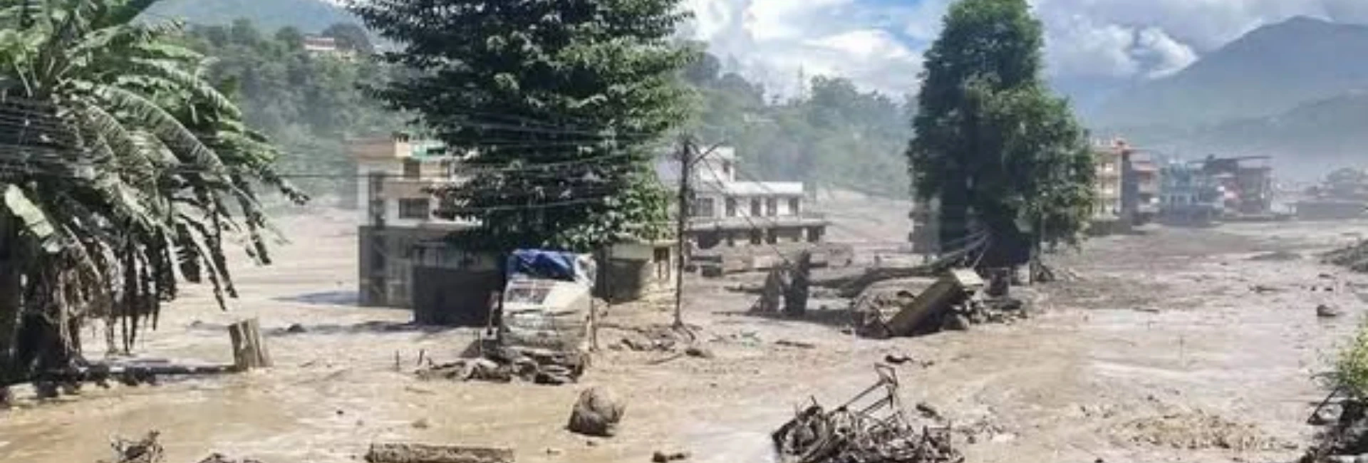
The devastating Bhote Koshi flood has once again highlighted the growing risk of sudden floods, glacier-related disasters, and other climate-driven hazards across Nepal’s Himalayan region. Experts say that while such natural disasters cannot be completely prevented, the loss of lives and property can be significantly reduced through stronger early warning systems, modern monitoring technology, and better cross-border information sharing.
The latest Bhote Koshi disaster has also underscored the urgent need for effective cross-border flood warning systems between Nepal and China, particularly in Himalayan areas where rivers and disaster events can affect communities downstream within a very short period of time.
Experts warn that the risk of sudden floods similar to the Bhote Koshi event exists in several other major Himalayan river systems, including the Sindhupalchok, Dolakha, Tamakoshi, Dudh Koshi, Arun, Gandaki, Kali Gandaki, and Bheri river basins.
For this reason, expanding early warning systems in high-risk mountain and river areas has become an urgent priority for Nepal.
Early Warning Could Help Save Lives
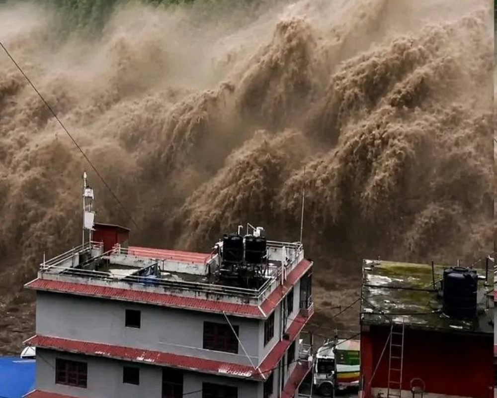
During the rasuwa flood, the relevant information network reportedly began receiving data at around 8:40 a.m. Efforts were then made to contact the concerned authorities, and information was received from the District Administration Office indicating that the flood was severe and had reached downstream areas.
Following the confirmation, warnings were circulated through available communication channels, including SMS alerts, to people in potentially affected areas.
Experts say that if reliable information had been available even earlier, authorities might have had more time to warn communities and move people to safer locations.
The time it takes for floodwater to travel from one location to another can be estimated through scientific studies using historical data, river-flow information, hydrodynamic modeling, and computer-based modeling.
However, sudden glacier-related floods are considerably more difficult to predict than conventional monsoon floods.
Predicting Glacial Lake Outburst Floods Remains Difficult
Nepal has made progress in forecasting conventional monsoon floods, but accurately predicting the exact timing of glacial lake outburst floods (GLOFs), glacier-related floods, ice avalanches, and sudden landslide-induced floods remains extremely challenging.
Experts say it is possible to identify areas that are at high risk, but determining exactly when a particular event will occur is difficult.
The situation has been compared with earthquakes. Scientists can identify areas with a high probability of earthquakes, but they cannot accurately determine the exact time an earthquake will occur.
Similarly, the potential risk of a glacial lake outburst or sudden glacier-related flood may be identified, but its precise timing cannot easily be predicted.
This is why experts emphasize that early warning is often more important than precise prediction.
CCTV Cameras, Sensors and Seismometers Could Strengthen Monitoring
Experts recommend expanding the use of modern monitoring technology in high-risk Himalayan areas.
CCTV cameras can be installed around glacial lakes and glaciers to provide continuous visual monitoring. In addition, water-level sensors, environmental monitoring equipment, and seismometers can help detect unusual changes and vibrations.
During the Bhote Koshi event, some seismometers reportedly recorded vibrations associated with the event. This has raised the possibility of incorporating seismic monitoring into future disaster early warning systems.
A combination of CCTV cameras, water-level sensors, seismic instruments, and other monitoring technologies could provide valuable information from remote mountain areas where conventional observation is difficult.
However, installing equipment is only the first step. The data must also be transmitted rapidly to authorities capable of issuing warnings and organizing evacuations.
Satellite Technology Is Valuable but Not Enough for Immediate Warnings
Satellite technology can play an important role in monitoring Nepal’s mountains and surrounding Himalayan areas. Satellite imagery from countries including China, India, and Japan can help researchers and authorities study glaciers, glacial lakes, landslides, river changes, and disaster impacts.
However, experts caution that satellite imagery alone is not sufficient for providing immediate warnings during a sudden flood.
Heavy cloud cover can make it difficult to obtain clear images of the ground at the exact time an event occurs. For immediate disaster alerts, ground-based monitoring stations and sensors remain essential.
Satellite imagery is particularly useful for understanding what happened after an event, assessing damage, and studying long-term changes in glaciers, lakes, and river systems.
The most effective approach would therefore be a combination of satellite monitoring and ground-based early warning technology
Nepal-China Information Sharing Needs to Be Strengthened
The Bhote Koshi flood has also highlighted the importance of stronger cooperation between Nepal and China.
Because many Himalayan rivers originate or pass through areas close to the international border, disasters occurring upstream can have rapid consequences downstream.
Experts say Nepal needs a more systematic mechanism for exchanging real-time information with China, particularly regarding sudden changes in rivers, glaciers, glacial lakes, and other hazards in the Tibetan region.
Nepal already has mechanisms for exchanging certain flood-related information with India. However, geographical, administrative, and communication challenges can make coordination with China more difficult.
Experts believe lessons from the Bhote Koshi disaster should be used to strengthen bilateral cooperation and establish effective real-time information-sharing mechanisms and monitoring stations on both sides of the border.
Satellite Communication Could Help Remote Mountain Communities
Many remote Himalayan communities do not have reliable mobile networks. In a major disaster, existing communication infrastructure may also be damaged or completely disrupted.
Where mobile networks are available, sensor data can be transmitted through local communication networks. However, in areas where mobile networks are unavailable, satellite communication can provide an important alternative.
Experts say that at minimum, a system should be capable of delivering immediate warnings to local police, municipalities, and district authorities.
Once local authorities receive the warning, they can begin evacuating vulnerable communities and settlements before floodwaters reach them
Funding, Technology and Skilled Personnel Remain Major Challenges
Establishing CCTV cameras, sensors, and monitoring stations in high-altitude Himalayan locations is expensive.
The challenge does not end with installation. Equipment needs regular maintenance, monitoring, and technical support.
Poor weather conditions and difficult terrain can make it extremely challenging for technical teams to reach remote locations when equipment fails.
Nepal, therefore, needs not only investment in technology but also long-term funding, skilled technical personnel, and reliable maintenance systems.
Without adequate resources, even sophisticated early warning infrastructure may fail to provide effective protection when it is most needed.
Expanding settlements along rivers are increasing disaster risk.
Another growing concern is the rapid expansion of settlements and infrastructure along rivers.
Over the past 10 to 20 years, areas that were once relatively empty or sparsely populated have seen the construction of houses, roads, bridges, markets, and other infrastructure.
Comparisons of older and newer satellite imagery show significant development along several river corridors.
This means that a natural flood can now cause far greater human and economic losses than it might have caused in the past.
The problem is therefore not only increasing natural hazards but also increasing exposure to those hazards.
Climate change is contributing to glacier melt, glacial lake expansion, and instability in some high-mountain environments, while human development continues to expand into vulnerable river corridors.
Experts therefore emphasize that disaster risk in the Himalayas must be understood as a combination of climate change, natural hazards, insufficient preparedness, and increasing human settlement in vulnerable areas.
Human Losses Remain Deeply Painful
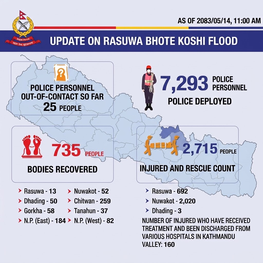
The devastating Bhote Koshi flood and associated flooding across surrounding river systems have caused widespread loss of life and extensive damage to infrastructure and property.
According to the latest figures released by Nepal Police, 735 people have lost their lives, while the exact number of people still missing remains unconfirmed. A further 2,715 people have been injured, rescued, or otherwise affected, with many receiving treatment in hospitals.
The disaster has caused extensive damage to homes, roads, 44 bridges, hydropower infrastructure, markets, and other critical public facilities.
In remote mountain areas, damage to roads and communication networks has further complicated ongoing search, rescue, and relief operations, making it difficult for emergency teams to reach some affected communities.
As rescue and recovery efforts continue, the scale of the disaster has raised urgent questions about how Nepal can better protect communities living downstream from high-risk Himalayan rivers and strengthen preparedness for future floods, glacier-related disasters, and other climate-related hazards.
Why Are Sudden Flood Disasters Becoming a Greater Concern?
Experts point to both natural and human factors behind the growing complexity of sudden flood risks in Nepal.
One of the major concerns is climate change and rising temperatures in the Himalayan region.
As temperatures rise, glaciers are losing ice, some glacial lakes are expanding, and certain glacier and lake systems may become increasingly unstable.
Under such conditions, an ice or rock avalanche, sudden release of water, or other high-mountain event can generate a powerful downstream flood.
At the same time, increasing development along rivers has placed more people and infrastructure directly in harm's way.
Heavy rainfall, glacier and glacial lake changes, avalanches, landslides, and human interference with natural river systems can interact to create increasingly complex disaster scenarios.
For this reason, experts say these events should not be viewed simply as isolated natural disasters. They are also connected to climate change, changing mountain environments, and weak preparedness and development in high-risk areas.
Important Safety Advice for Trekkers and Travellers
The Bhote Koshi disaster also carries an important message for trekkers and travelers planning to visit affected or nearby areas.
If you have a trek planned in or around the affected region, do not rely solely on your original itinerary. Check the latest information from local authorities, your trekking agency, and your guide before traveling.
Routes and infrastructure can change rapidly following a major flood, landslide, or other disaster.
Trekkers should:
- Avoid waiting in or near affected areas if authorities advise evacuation or relocation.
- Do not attempt alternative routes through disaster-affected areas simply to complete a trek or take photographs.
- If you are already in Nepal, contact your guide or trekking agency and discuss whether your itinerary should be changed.
- Travelers who have not yet started their journey should consider postponing or rescheduling travel to seriously affected areas until reliable safety information is available.
- If you are already in a disaster-affected area, follow instructions from local authorities and move to a safe location when advised.
- In an emergency, contact the relevant Nepal emergency and security authorities and follow official instructions.
Routes and destinations such as Langtang, Gosaikunda, the Tamang Heritage Trail, Syabrubesi, Timure, and the Bhote Koshi–Trishuli corridor should be assessed carefully according to the latest local conditions before traveling.
For travelers, changing an itinerary after months of planning can be disappointing. However, during a disaster, flexibility is not simply a travel inconvenience; it can be an important part of protecting travelers, guides, local communities, and emergency response teams.
Travelers should also avoid putting additional pressure on rescue routes that may be needed for helicopters, security personnel, medical teams, and relief supplies.
What Should Nepal Prioritize Now?
The Bhote Koshi flood provides a serious warning for Nepal's Himalayan communities and river corridors.
Experts say immediate action should focus on two major areas.
1. Expand Early Warning Systems
Nepal should expand early warning systems, water-level sensors, CCTV cameras, seismometers, and other monitoring technologies in high-risk Himalayan and river areas.
These systems should be connected to local governments, police, disaster management authorities, and communities so that warnings can reach people quickly.
2. Manage Development in High-Risk Areas
New settlements, roads, bridges, and other infrastructure should not be developed without proper disaster risk assessment.
Development planning needs to consider flood pathways, river behavior, landslide hazards, and potential glacier- and glacial-lake-related risks.
Reducing exposure to hazards can be just as important as improving emergency response.
Early Warning Is a Lifesaving Investment
The Bhote Koshi disaster demonstrates that Nepal cannot completely eliminate natural hazards, but it can reduce the scale of their consequences.
Better monitoring, faster communication, stronger cross-border cooperation, and responsible land-use planning can provide communities with the time they need to move to safety.
The most important lesson from the disaster is simple:
A disaster may not always be predictable, but a timely warning can save lives.
For Nepal's increasingly vulnerable Himalayan region, early warning systems should therefore no longer be treated as a luxury. They should be regarded as a lifesaving investment and an essential part of national disaster preparedness.


.webp)