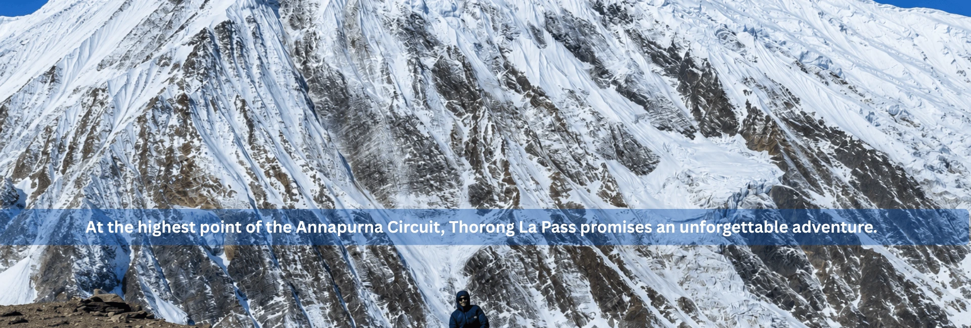
Nestled high in the Himalayas of Nepal, Thorong La Pass stands as one of the world’s most iconic trekking crossings. At an impressive height of 5,416 meters (or 17,769 feet), this is more than just another location on the map; it's actually the highest and most significant point within this trek on the Annapurna Circuit.
In addition to being physically high up in the sky, the air is thinner than normal; strong winds whip through and cause prayer flags to fly all around. Further, you get an awful feeling when you're up this high that you're very close to the sky.
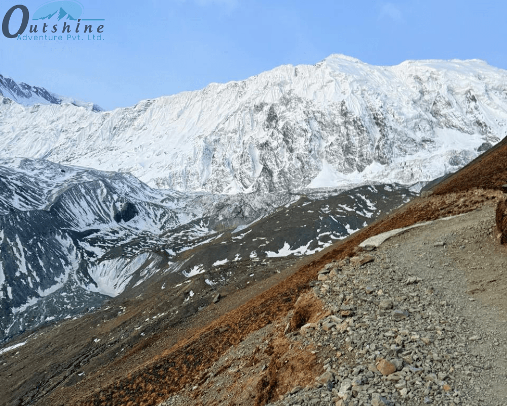
Crossing this pass is a big achievement for trekkers. It marks a change from the green and forested valleys of central Nepal to the dry, high mountain lands that look like the Tibetan Plateau. But reaching the top is not easy.
There are many factors a trekker must take into account when planning to hike through the Thorong La Pass. Some of those factors are altitude, physical fitness, elevation gain/loss, the unpredictable weather of high mountains, etc. All play a significant role in any successful attempt to cross the Thorong La Pass.
This guide will cover everything you should know in order to ensure that you cross the Thorong La Pass safely and successfully.
Where is Thorong La Pass?
The Thorong La Pass stands as the highest elevation along the Annapurna Circuit. It is an epic trekking journey that surrounds the Annapurna massif. The pass also serves as a crucial "bridge" between two very different worlds.
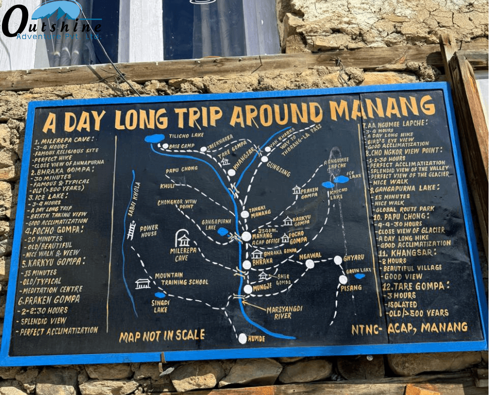
The first world is in the east, the Manang District. It is best described as having alpine forests, glacial lakes, and a lush green valley through which the Marsyangdi River flows.
On the west side of the pass is the Mustang District, which is the "forbidden kingdom." It has a dry, almost lunar-like topography with strong ties to the Tibetan culture.
Elevation Profile
Understanding what an elevation gain involves is critical to being mentally prepared for the scale of the climb to the Thorong La Pass. Additionally, along the way, elevation rises gradually:
Manang (3,540 m) is the primary place where you stage for your trip, and it is also a place where you truly start to acclimate to the environment.
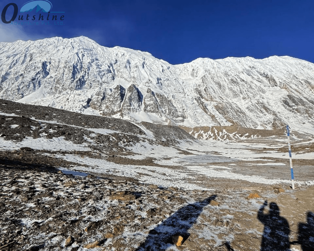
Thorong Phedi (4,450 m): This is a small settlement located at the base of the Thorong La Pass. Note: "Phedi" is the Nepali word that means "foot of the hill."
High Camp (4,900 m): This is the last stopping place before the Thorong La Pass. If you stay here, it will save you roughly an hour on your summit day; however, it also increases your chances of altitude sickness.
Thorong La Summit (5,416 m): This is your final destination of the journey.
Muktinath (3,800 m): This is the place where you will finish your journey after descending from the Thorong La Pass. This is a holy pilgrimage site, and you will descend approximately 1,600 m.
Why Is It Called the World’s Highest "Trekking" Pass?
In the world of mountaineering, it’s an accepted reality that there is an unspoken line between “climbing” and “trekking.”
While it is true that other passes, such as those found in the Karakoram Range or the depths of the Tibetan Plateau, are technically higher, it is still accepted that Thorong La is the highest trekking pass due to its accessibility.
Technical Simplicity vs. Physical Reality
Unlike other peaks, such as Annapurna I or Dhaulagiri, which demand crampons, fixed ropes, ice axes, and technical know-how, Thorong La is, for all intents and purposes, an extremely long, extremely high walk.
In peak season, the route is essentially a highway. In normal conditions, you don’t need ropes, harnesses, or carabiners; all you need is good, sturdy boots and an enormous amount of mental fortitude.
The Invisible Challenge: Oxygen at 5,416m
The atmospheric pressure at the summit of Thorong La is considerably lower than at sea level. In effect, at the top, you are essentially breathing 50% less oxygen than you would at the ground. This reality changes everything:
- Even the most fit athletes find themselves gasping for air after ten steps.
- Your body diverts blood away from your stomach to your heart and lungs, making it harder to process food.
- High-altitude Cheyne-Stokes breathing (periodical breathing) can make the nights at High Camp feel restless.
The Crossing Day: What It Really Feels Like
Crossing Thorong La Pass is not a normal day for trekking. It is a big day in the journey.
The Pre-Dawn Start
The day begins very early, around 3:30 AM to 5:00 AM. This is due to two reasons:
- Strong winds begin around midday. The wind is very cold and dangerous.
- The walk down to Muktinath Temple is very long. You have to descend 1,600 meters. It takes 4 to 6 hours and is very hard on your knees.
You walk in the dark with the headlamp to see the path. The cold is very harsh, with temperatures dropping to -15°C to -20°C.
The False Summits
One of the most difficult things you experience on this mountain climb is the false summits. Many times, you think you have reached the top. But when you reach the top, you see more mountain climbing ahead. It is a very frustrating experience.
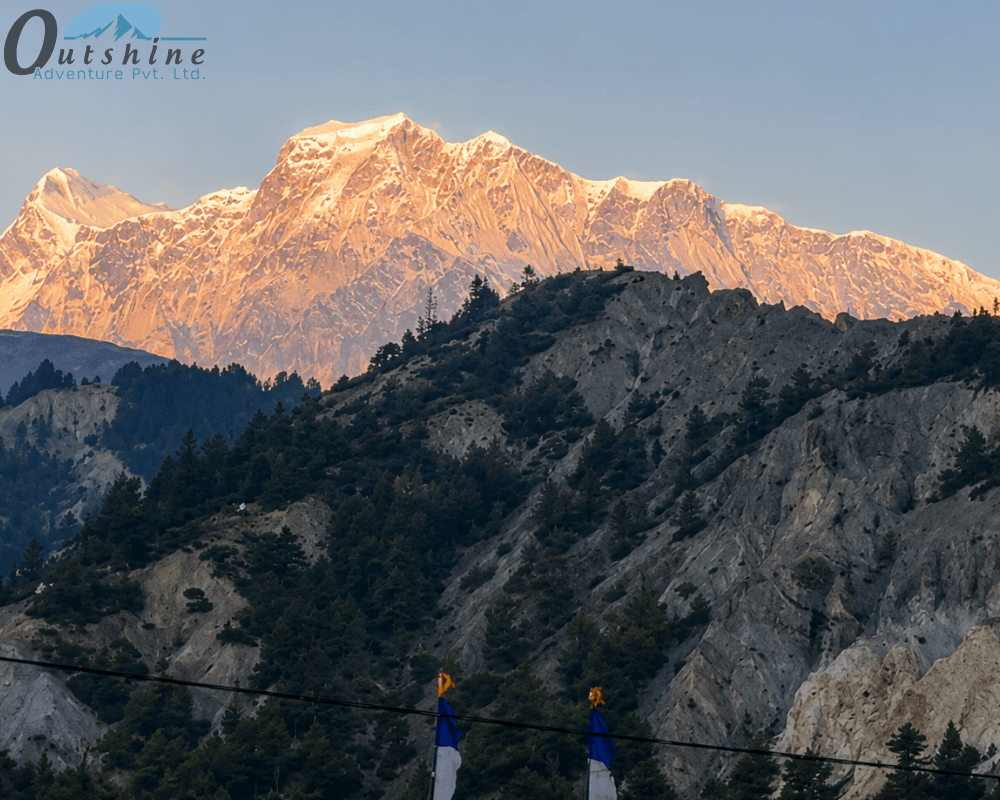
As you climb, the sun rises. The mountains of the Annapurna Range and the Dhaulagiri Range start to look beautiful with a pink and yellow hue. In this moment, you forget your tiredness for a short while.
The land around you is very dry and open with rocks and snow. It is very different from the green lands you walked through.
Reaching the Summit
You know you are close when you see many colorful prayer flags waving in the wind.
At the top, there is a small teahouse where you can get a cup of tea. It may be expensive, but it feels very special.
People feel very happy and very tired at the same time. They hug each other and take pictures in front of the “Thorong La 5416m” sign.
You can see mountains all around you. But you’re not yet done. This is just halfway to the top. You can’t stay here for long because you’re at such a high altitude. You must go down after 15 to 30 minutes.
Difficulty Level
How difficult is Thorong La Pass? The answer to this question depends entirely on your preparation. It is generally considered a "challenging" pass, but it is a "physical challenge" rather than a "technical challenge." Factors that Increase Difficulty:
- You will have been trekking for 8 to 10 days when you reach the pass. You will be in a state of considerable caloric deficit, and your muscles will be fatigued.
- Many trekkers find the trek down to Muktinath to be more difficult than the trek up. It is steep and over scree, which is very slippery.
- It is a "long walk" when the sun is out, and an "alpine survival experience" when there is snow.
Altitude Sickness
Acute Mountain Sickness (AMS) is the single most important phenomenon to respect. Your body will be in a hypoxic state at 5,416 meters.
Recognizing the Symptoms
AMS doesn’t care how old you are or how fit you are. AMS is all about how well your body adapts to the lack of oxygen.
Mild Symptoms: Headache, loss of appetite, nausea, and mild dizzy spells.
Severe Symptoms: HAPE/HACE: Excessive breathlessness at rest, inability to walk in a straight line, confusion, and a dry, persistent cough with frothy sputum.
The Golden Rules of Acclimatization
- Don’t ever skip the acclimatization day at Manang. Take this day to ascend to Gangapurna Lake or Ice Lake at 4,600m and then descend back to Manang to spend the night. The rule is to "Climb High and Sleep Low."
- Drink 3 to 4 liters of water a day. Dehydration will bring on AMS.
- Garlic soup is a traditional remedy in the Himalayas. Though not scientifically
"proven" to cure AMS, the vasodilation properties of garlic are believed to help.
- Listen to Your Guide. Your guide knows AMS better than you do. He/she will be able to see the signs of AMS before you do. If they say descend, descend. The mountain will still be there tomorrow, but your life is more important.
Gear That Actually Matters
Packing list: every ounce counts on the Annapurna Circuit. However, for the Thorong La crossing, specific gear can be the difference between a successful summit and a miserable retreat.
The "Big Three" for the Pass:
- The Down Jacket: It must be rated for subzero weather. Even if it’s warm when you start at 8:00 AM in the lower valleys, you will need this for the 4:00 AM summit push.
- Trekking Poles: These are essential for the 1,600-meter descent. They reduce the impact on your knees by up to 25%.
- Microspikes: Even in the "dry" season, patches of ice can linger on the pass. A pair of lightweight spikes that slip over your boots can prevent a dangerous fall.
Don't Forget:
- High-SPF Sunscreen and Lip Balm: The UV rays at 5,000 meters are incredibly intense. "Snow blindness" and severe sunburn can happen in less than an hour.
- Insulated Water Bottles: Ordinary plastic bottles will freeze solid within an hour of your pre-dawn start. Use a thermal sleeve or a Nalgene wrapped in a wool sock.
- Headlamp: You cannot cross the pass without a headlamp. Be sure to have new batteries!
The Best Time to Go: Seasons and Safety
There are essentially two trekking seasons in Nepal, and each has its own set of conditions.
Spring (March to May)
Pros: The weather is getting warmer. The rhododendrons are in full bloom in the lower regions. There is more snow on the pass, which is good for photography.
Cons: There is a possibility that the snow might be deep enough to temporarily close the pass.
Autumn (September to November)
Pros: This is the "Goldilocks" season. The air is very clear because the monsoons have washed all the dust off the air. The weather is good, and the views of the mountains are very clear.
Cons: This is the peak season, and the trails and teahouses are very crowded.
Winter and Monsoon
Winter (Dec–Feb): This is not a good season unless you're an experienced trekker. There is often too much snow on the pass to cross it, and it gets very cold – sometimes as low as -30°C.
Monsoon (June–Aug): The Manang side is not good because of the leeches. However, the Mustang side is in the rain shadow and is dry. The only problem is that the road to the trekking point might be affected by the landslides.
Permits Required
To minimize impact on the environment and to ensure that trekkers are safe, trekking in the Annapurna region is heavily regulated. You cannot just show up and go walking.
Permits Required:
- Annapurna Conservation Area Permit (ACAP): This permit takes care of the trails and supports the local plants and animals.
- Trekkers’ Information Management System (TIMS): This permit allows for tracking of trekkers through checking into police checkpoints along the way so that local authorities can know the last place you were in case of a problem.
NOTE: Recently, trekking with an approved guide has been strongly recommended (and in some cases compulsory)
Beyond Trekking: The Cultural Experience
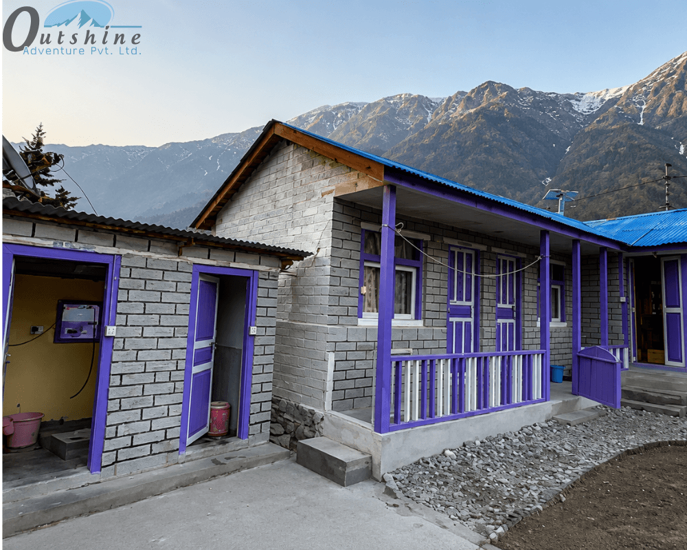
While the physical trek over Thorong La is an attraction, it is the cultural experience that lingers in your mind. The Annapurna Circuit is a "tea house trek," which means you stay in local lodges rather than luxury hotels.
The People of the Mountains
In the Manang district, you will encounter the Manangi people, known for their history of trade. The villages here abound in "Mani" stones and large Buddhist stupas. In Mustang, it is the Thakali and Gurung people.
Authentic Moments
The Prayer Wheels: Always turn them in a clockwise direction, as it is a sign of respect and sends out the prayers on them into the world.
The Food: While "Dal Bhat" is the standard fare in Nepal, do not forget to try the authentic Thakali Thali in Mustang. This is said to be the best traditional food in Nepal.
Apple Orchards: After descending to Muktinath and Kagbeni, you enter apple country in
Nepal. You must try the local apple pie and "Marpha brandy."
Why Trek With a Licensed Local Company?
If you want to save money, you may want to try going to Thorong La by yourself. However, there are a lot of reasons why going through a licensed operator like Outshine Adventure when going to Thorong La is a better option:
- When you have a local guide who is familiar with the area, they will have the logistics and contacts necessary to coordinate a horse or helicopter evacuation for you if something unexpected happens
- The guides know which teahouses have the best food, which areas of the trail are prone to rockfall, and the names of all the peaks surrounding you, making them extremely knowledgeable about the area.
- Having a guide take care of all the logistics (permitting, transport, lodging reservations, etc.) means that you can focus on breathing and walking rather than stressing about logistics.
- When you use a local agency, you are supporting the local economy because it means your tourism dollars are going to the Nepalese people who maintain the trails. If you are interested in personalized itineraries with a focus on safety, check out the information on this website: https://www.outshineadventure.com/.
Conclusion
The most important lesson for those attempting Thorong La is that the mountain doesn’t care about your timeline.
Crossing the Thorong La Pass teaches you humility. You have no control over the weather or your body. Some days you will enjoy the glorious sun and feel the sense of victory. Conversely, there will be other days when you will fight through white-outs to endure the elements.
The only "achievement” is not the photograph taken at 5,416 m, but rather the 10 days of trekking to that point: the cold mornings, the conversations with locals, the experience of sipping hot lemon tea in a small, wooden lodge, and the quiet acceptance of how much your body can endure.
Once at the top and surrounded by the majestic Annapurna mountains, you realize that you are not “conquering” a pass; rather, you are a guest who has been graciously welcomed to pass through the pass. This awareness is something you will carry with you long after you have returned home.

-(1280-x-720-px)-(6-x-4-cm)-(1000-x-800-px)-(1920-x-650-px)-(1000-x-800-px).webp)
.webp)